Canarias.app travel guide · La Palma
La Palma Travel Guide: What to See, Beaches, Getting There and Tips | Canarias.app
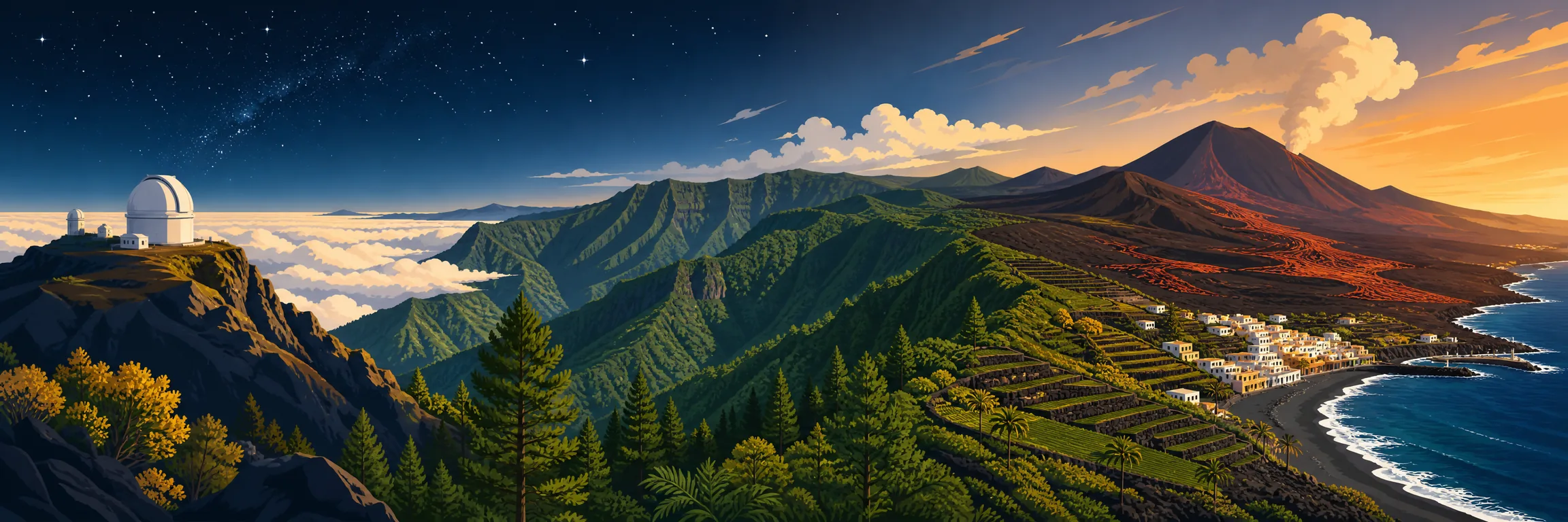
La Palma is the Pretty Isle (la Isla Bonita) — a UNESCO Biosphere Reserve in its entirety and a designated Starlight Reserve with the cleanest stargazing skies in Europe. Across just 708 km² it packs in the vast crater of the Caldera de Taburiente, the Tajogaite volcano (born in the 2021 eruption, visited only with a guide), laurel forests, salt pans and black-sand beaches. This is the Canaries' paradise for hiking and astronomy: green, rugged and refreshingly free of the crowds.
What to See
The Tajogaite volcano, born during the 85-day eruption of 2021, can only be visited with an authorised guide along a roughly 6 km trail that reaches close to the cone. The Caldera de Taburiente (a National Park since 1954) is an erosion crater with walls towering up to 2,000 m, home to the only permanent watercourse in the Canaries and the colourful Cascada de Colores. High above, the Roque de los Muchachos (2,426 m) crowns the observatory and the Gran Telescopio Canarias. Rounding out the list are the Los Tilos laurel forest with the tunnel walk of Marcos y Cordero, the salt pans and lighthouse of Fuencaliente, and the Renaissance old town of Santa Cruz de La Palma.
Beaches and Pools
La Palma's sand is black and volcanic. Los Cancajos (Breña Baja, beside the airport) is the most relaxed resort-style beach, with sheltered coves and family amenities. Puerto Naos, in the Aridane valley, is reopening gradually after CO2 monitoring, so it pays to check which sections are open before you go. For wild, scenic bathing, head to Nogales beach in Puntallana; in the south, Echentive was created by lava from the 1971 Teneguía eruption. When the swell picks up, the safe bet is the natural pools of La Fajana (Barlovento) and Charco Azul (San Andrés y Sauces), purpose-built rock pools, while Charco Verde offers a small sandy cove next to Puerto Naos.
Getting Around
Most visitors fly into La Palma airport (SPC), about 8 km from the capital: inter-island hops with Binter and CanaryFly (30-45 min) plus year-round direct links to Madrid and Barcelona. By ferry, Fred Olsen connects Los Cristianos (Tenerife) with Santa Cruz de La Palma in around 2 hr 30 min, ideal if you're bringing a car. A hire car is well worth it: the island is mountainous, the highlights are scattered and the roads are winding. TILP buses serve the main routes (capital, Los Llanos, airport), but services to trailheads and viewpoints are limited. To reach Los Brecitos in the Caldera, the usual approach is a 4x4 taxi.
When to Go and Weather
The climate is subtropical and mild all year, hovering around 22°C on average, with warm, dry summers and slightly cooler, wetter winters. La Palma has sharply defined microclimates: the north and east (Los Tilos, San Andrés y Sauces) are green and damp thanks to the trade winds, while the west and south (Aridane, Tazacorte, Fuencaliente) are drier and sunnier. The sea of clouds usually sits below the summits, leaving clear skies up top for stargazing. Spring and autumn are ideal for hiking; summer is best for the beach. Expect cold and wind at the Roque and in the Caldera in any season.
Where to Stay
Santa Cruz de La Palma makes the best cultural base: a historic centre of wooden balconies, a port and easy access to the north and east. Los Cancajos (Breña Baja) has the most resort-style beach offering, very close to the airport. The Aridane valley and Puerto Naos boast the finest weather and the best beach in the west, though the reopening is partial, so confirm before booking. El Paso, in the centre, is perfect for the Caldera de Taburiente and the Tajogaite volcano. The north (Barlovento, Garafía, San Andrés y Sauces) is the realm of rural cottages, laurel forest and astro-tourism, peaceful and low-key in keeping with its Biosphere Reserve character.
Food and Tips
Palmeran cooking shines with papas arrugadas (wrinkly potatoes) and mojo sauce, the protected-origin queso Palmero cheese, often smoked, plus almogrote and the wines of the DO La Palma with their historic malvasía. There's no shortage of bananas, fresh fish from Tazacorte and sweets such as príncipe Alberto. Key tips: never tackle Tajogaite alone — guide and advance booking only; wild camping in the Caldera is free but needs a permit in advance; for Marcos y Cordero, pack a torch and waterproof for the dripping tunnels; and wrap up warm at the Roque. La Palma is the Canaries' number-one trekking destination: always bring proper footwear and water.
FAQ
Questions about La Palma Travel Guide
Can you visit La Palma's volcano from the 2021 eruption?
Yes. The Tajogaite volcano, which emerged in the 2021 eruption, can only be visited with an active-tourism company or authorised guide and advance booking. There is a single approved trail of around 6 km and roughly 2 hours, of low-to-moderate difficulty, ending near the cone at 1,131 m. Going it alone is not permitted. As an alternative, you can see the lava deltas (fajanas) from a boat departing Tazacorte harbour, while the Tajuya and El Tiempo viewpoints offer good views, reachable by car and free of charge.
How do you get to La Palma?
By air, into La Palma airport (SPC), about 8 km from the capital. There are inter-island flights with Binter and CanaryFly (30-45 min) and year-round direct links to Madrid and Barcelona, plus international routes mainly from Germany, the UK and northern Europe. The other option is the Fred Olsen ferry from Los Cristianos (Tenerife) to Santa Cruz de La Palma, taking around two and a half hours, very handy if you want to bring your own car.
Why is La Palma famous for its stars?
Because it has some of the clearest, darkest skies in the northern hemisphere. The Roque de los Muchachos Observatory, at around 2,400 m, houses the 10.4 m Gran Telescopio Canarias and is considered the second-best site for astronomy after Mauna Kea. The Sky Law of 1988 protects the island from light pollution, and the sea of clouds usually sits below the summits. La Palma is a Starlight Reserve and has astronomical viewpoints and certified guides for observing the Milky Way.
What's the situation with Puerto Naos beach?
Puerto Naos, the great black-sand beach of the Aridane valley, was evacuated after the 2021 eruption due to CO2 emissions and is reopening gradually. The southern half of the beach is now accessible and more than 1,200 reopenings of homes and businesses have been authorised, backed by one of the densest CO2 sensor networks in the world. As the situation keeps evolving, it's worth checking official Cabildo sources for which areas and amenities are open before planning your visit.
How many days do you need to see La Palma?
To enjoy it without rushing, four to seven days is ideal. With that window you can devote a day to the Caldera de Taburiente, another to the Tajogaite volcano with a guide, a night of astronomy at the Roque de los Muchachos, a day to the Los Tilos laurel forest and Marcos y Cordero in the north, and another to the south around Fuencaliente with its salt pans, volcanoes and wineries. If hiking is your sole focus, the island offers far more, with major routes such as the Ruta de los Volcanes, the GR-130 and the GR-131.
Saca más a tu visita
Entradas, tours y excursiones
Hay excursiones, tours guiados y actividades en La Palma para redondear tu visita a Guía de La Palma.
Ver excursiones y toursKeep exploring
More to see in La Palma
Tours and activities in La Palma
Loading tours…
